Thursday, August 1, 2013

Natures and Interesting In Bau. Sarawak.

#PLACES THAT MUST BE VISIT

Tasik Biru
(Blue Lake)

Short history: The gold mining activity here ended in 1921. In early 1990s, the mining activity started again; somehow sinkholes began to show up here and there, around Bau town. After sometime, they decide to shut down the mining for the 2nd time.

Fairy Cave

This climbing area has 8 separate walls with over eighty climbs here. Difficulties ranges between 5-8 (French grading).  All climbs have glued in (Hilti RE 500) and fixed hangers on expansion bolts certified by International Mountaineering and Climbing Federation (UIAA).  Located 6-km away from the town of Bau, the Fairy Cave area comes under the Krokong village committee made up of 17 smaller villages.The Bidayuhs here are the ancestral custodians of the cave area. Most of them here are Catholics and their parish of 7 villages has worked with local climbers in carrying out community service at the climbing areas.

Wind Cave

The Wind Cave Nature Reserve is part of the Bau Formation, a narrow belt of limestone covering about 150 sq km of Southwest Sarawak. Due to the comparatively soft and soluble nature of limestone, and the intense tropical rainfall of the region, the whole of the Bau Formation is intersected with caves. Whilst many caves of the Bau Formation are remote and inaccessible, the Wind Cave is within easy reach of Kuching and is a popular day trip and picnic destination. The Wind Cave Nature Reserve covers 6.16 hectares and includes the cave itself and the surrounding forest.

#FLORA AND FAUNA

The Wind Cave’s has been gazetted as a nature reserve not just to protect the cave and its inhabitants, but also to conserve a number or rare species in the surrounding limestone forest. Amongst the small to medium sized trees and shrubs are some very rare palms, including Arenga pinnata (called Inyok in the local Bidayuh language), Arenga undulatifolia (Opip in Bidayuh) and the gigantic Calamus ornatus (Wi jelayan in Bidayuh).here
Squirrels, shrews and a variety of birds can be found along the river and the limestone hill. Black nest swiftlets can be seen and heard inside the cave, as well as 14 species of bat. Twelve distinct species of snail have also evolved in the caves and the covering hill, each unique to its own limestone habitat.

#SHOPPING

Serikin Weekend Market

Serikin is a small Dayak Bidayuh village in Kuching Division, Sarawak, Malaysia. The town is located about 15 km from Bau town and 80 km from Kuching city. Kampung Jagoi Serikin is famous for her week-end market to local tourists from Malaya and Sarawak. In the week-end market, you can find numerous items ranging from batik, handicrafts, fish, birds, turtle eggs, herbal products and jamu, electrical items, electronic items, male and female workers, jungle produce and exotic meat.People of Serikin, or BiRikin, originated from Kupuo' Jagoi Dorod.

History Of Bau, Sarawak.


Maybe it is not a well known fact, that, if it wasn't because of Bau, James Brooke, the first White Rajah, would never have come to rule Sarawak.  The name 'Bau', only came into being in the early 1857, after the abortive Bau Chinese Rebellion of 1857.  In the early 1800's, the old name of Bau District was 'Upper Sarawak'. There was no such place called Bau. The old name of Bau Town was 'Mau San' or 'Bukit Mau'. This Settlement was established in between 1820 - 1830 by Chinese Miners from Sambas, Indonesia, after the discovery of Gold and Antimony in the district. History has shown that Bau is one of the oldest and richest (in term of mineral resources) districts in Sarawak. In the olden days, Bau was not only a well known mining district but also one of great historical importance.

#HOW BAU GET ITS NAME

The Chinese miners in 'Mau San' (Old Bau) was already well established since 1820. They were well contented in their free way of life due to loose control and poor administration by Brunei.  But after James Brooke was installed as Rajah of Sarawak in 1841, he imposed taxes, prohibited direct trading of opium and wine with foreign countries, prohibited direct export of gold and antimony. In 1856, the Rajah allowed the formation of the Borneo Company to mine gold in Bau.  The above factors caused the Chinese Miners to rebelled against the Rajah. Obeying the new rules of a White Devil was too much.  The rebellion started on 18th February 1857. 600 men paddled down Sarawak river from Pangkalan Bau to Kuching. They attacked Kuching and the Astana in the early morning of 19th February. Somehow, James Brooke manage to escape by swimming across the Sarawak river. The Chinese Miners burnt down the Astana, killed and beheaded 5 Europeans.
The rebellion was doomed to fail from the beginning. There was no proper planning, the Miners lacked weapons and proper military training. There was no support from the local community, especially the natives.  Thus when news came that, the Tuan Muda (Charles Brooke) with the aid of Iban warriors from second Division (Skrang) was coming to avenge the death of the Europeans, the Chinese Miners decided to retreat from Kuching to Bau.  On 22th February 1857, they retreated upriver. But at Jugan Sinawan they were attacked and defeated by the combined forces of Ibans and Malays loyal to Brooke. More then a hundred Miners were killed, including their leader. Dead and decomposed bodies were found everywhere. The place where this happened is now called 'Buso' (in malay, it means rotten/stink/decomposed).
The remaining 100 miners retreated to Bau, collected their families and belongings and escaped to Sambas, Indonesia. Most of them perished on the way.  The families that have lost their men and were unable to escape to Indonesia, hid in the Ghost Cave or fled into the jungle. There were no mercy for them. Each and everyone were hunted down and killed by the Rajah forces. Those who hid in the Ghost cave were burnt or suffocated to death.(a few hundred women and children). 'Mau San' Chinese Mining Settlement was set on fire on 25th February 1857. Total number of Chinese killed was about 2000.  The burnt bodies in Ghost caves and decomposed bodies around 'Mau San' produced bad smell for weeks. Because of the bad smell, it was believed that 'Bau' (it means bad smell/smelly in Malay) got its name.


#HOW BAU GET ITS NAME_BIDAYUH VERSION

The Chinese from Sambas, estabished their settlement in Mau San (now called Bau Lama), in the 1820's, near to the present Bau Town. It was centered around the goldmine. The Sarawak Kanan river (sungei Pedie) flow close by. The river was their source of water supply and transport. As the settlement grew, the Bidayuh living in the area started to barter trade with the Chinese and some even found employment in the mines. The Bidayuh started to call the settlement 'Kupuo Baauh' or New Village. To a non-Bidayuh it is hard to pronoun 'baauh' and the name was corrupted to 'Bau'. This is a more plausible origin to the name Bau. Nothing to do with bad smell.

Nature of Gunung Gading

       Gunung Gading National Park has a very special star attraction - the Rafflesia, the world’s largest flower - and the park is one of the best places in Asia to view the Rafflesia’s spectacular blooms. Gunung Gading sprawls across four jungle-clad mountain peaks, and its dense primary rainforest is criss-crossed by crystal clear streams and waterfalls.here

Rafflesia

Gunung Gading was gazetted as a park in 1st August 1983 primarily to provide a conservation zone for the protection of the Rafflesia. It was opened to the public in 1994 and visitors can now view one of the most spectacular plants found on the planet. The park is easily accessible from Kuching on a day trip. Those wishing to stay longer can enjoy Gunung Gading’s other attractions - particularly its rainforest scenery, waterfalls and jungle trails. Some of these trails lead to the peaks of the mountains that make up the park and offer challenging jungle treks.

#RAFFLESIA

The Rafflesia, the world’s largest flower, is a parasitic plant found only in Southeast Asia, and then only in sub-montane hilly forests at elevations between 400-1,300 metres. Sir Stamford Raffles and Dr Joseph Arnold were the first Europeans to discover the Rafflesia. In 1818, whilst on a field trip near the town of Bencoolen (Bengkulu) in Sumatra, they came across a huge specimen that measured 97 cm in diameter. This species was later named the Rafflesia Arnoldi. When news of the discovery reached the botanical community in 1820 it caused quite a sensation with murmurings of disbelief.

There are thought to be 17 species of Rafflesia, some of which may already be extinct. Three species are found in Sarawak - the Rafflesia Pricei, Rafflesia Arnoldi and Rafflesia Tuan-Mudae, which is actually a type of Arnoldi. Only one species, R. Tuan-Mudae, is found at Gunung Gading.
The Rafflesia is as unusual as it is spectacular. Much of the flower’s biology remains a mystery to this day. It has no specific flowering season and it has no roots, leaves or stem. The Rafflesia depends on a host vine - the tetrastigma, a member of the grape family. Scientists are still unsure why the Rafflesia associates itself with the tetrastigma vine or how the seeds of a Rafflesia germinate and grow. What is known is that threads of tissue spread out within the vine and absorb nutrients. After 18 months a small dark brown bud appears.

Such a long period of growth means that there is a high risk of damage; even when a bud forms there is no guarantee that it will mature into a Rafflesia flower. A bud takes nine months to mature, when it may measure up to 16 cm in diameter, and studies have shown that a high percentage of buds do not survive, as they are susceptible to both drought and heavy rain.

After nine months the brown ‘leaves’ of the cabbage-like bud open, revealing the underside of the petal-like lobes. It takes several hours for a flower to open fully. There are usually five thick and fleshy red-coloured petals, covered in lighter coloured spots, warts and blotches. The Rafflesia only blooms for 3-5 days, before it starts to blacken and rot. Although it is quite common for a number of buds to occur in a cluster at the same site, it is rare for two plants of the same cluster to bloom at the same time.

Rafflesia flowers are either male or female, and therefore cannot self-pollinate. For pollination to take place, a male and a female flower must bloom at the same time and pollen must be transported over considerable distances. In the Rafflesia’s case pollination is carried out by carrion flies, so whilst in full bloom the Rafflesia gives off a foul smell of decaying flesh to attract them. Seeds are thought to be dispersed by rodents and other small mammals which eat the flowers. Scientists remain baffled, however, as to how the tiny seeds infest the roots and stems of the host vine.

Loss of habitat is the greatest threat to the survival of the Rafflesia. Its reliance on the tetrastigma vine does not help matters. With other endangered species it is possible to implement a range of conservation measures such as trans-location and the establishment of nurseries. However, these measures are not possible with the Rafflesia due to its very high degree of specialisation. The establishment of totally protected conservation zones is the only way to preserve this unique plant.  Gunung Gading National Park in Southwest Sarawak is such a conservation zone. Gazetted in 1983, the park covers an area of 4,106 hectares and forms a safe and secure habitat for the protection of the Rafflesia.


#WILDLIFE


Gunung Gading is home to a range of animals including civet cats, wild boar, small deer, porcupines, monkeys and giant squirrels. However, as the Park is surrounded by villages, most of the wildlife stays deep in the jungle, on the upper slopes of the park’s mountains, and therefore Gunung Gading is not an easy place for spotting wild animals. Visitors who opt for a summit trek are more likely to see some of the park’s wildlife. 

#WATERFALL

This is the easiest and shortest trail in the park. The trail follows a river and passes seven waterfalls, although not all of the waterfalls are accessible. Waterfalls 1, 3 and 7 are signposted. If you need to break the trek up, waterfall 3 provides a pleasant resting spot. It is only a 10 metre detour from the main trail. The whole trail passes through some great jungle scenery before reaching the final waterfall, and a perfect dip pool surrounded by forest.
#BATU BERKUBU

Batu Berkubu, on the slopes of Gunung Sebuloh, served as communist base camp during the insurgency. Although it is often called a cave it is in fact a huge rock which along with the surrounding trees provides a cave-like sheltering area. The trek from the Summit of Gunung Gading to Batu Berkubu is relatively easy, taking about 2 hours to cross a valley.

#GUNUNG GADING SUMMIT TRAIL

First follow the red and white Waterfall Trail until you reach the junction for the seventh waterfall. The trail’s marking then changes to yellow and red. This is the start of Gunung Gading Summit Trail. From the junction it takes another two and a half hours to reach the summit, which was the location of a British army camp during the communist insurgency of the 1960’s. The remnants of the camp - a helicopter pad, water tank and barbed wire fencing - still remain to this day, and appear somewhat out of place in the middle of a national park. However, they are of historical significance and the park staff intend to preserve the summit area as it has been for the last 30 years.


History Of Lundu, Sarawak.


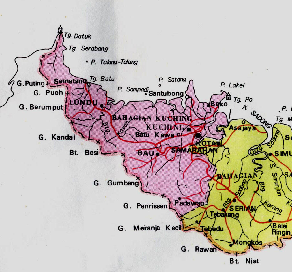
As far as anyone knows, the lands around Lundu was empty of people until relatively recently. Although the main river is called Batang Kayan, "the Kayan river," there is no evidence at all that any Kayan people ever lived there.. In the middle of the eighteenth century a group of Bidayuh people from near Bau migrated and settled on the west bank of the Batang Kayan, where Kampong Stunggang Melayu now stands. They came to be called the Dayak Lundu, and though the last member of the tribe died in the 1960s, you can still see the grove of durian trees they planted. The name "Lundu" itself is taken from a small catfish that abounds in the Sungai Lundu which flows down from Gunung Gading.


Batang Kayan River

Towards the close of the eighteenth century three groups of people at the same time came separately to make their homes in Lundu. From the east came the Ibans. These Ibans were originally from Balau on the west bank of the Batang Lupar. They spoke, and still speak their own dialect of Iban and traditionally had been enemies with the Ibans of the Saribas and Paku areas. A group of Balau people decided to mindah, migrate. They stopped first at Sebuyau, and from there travelled west. From their stay at Sebuyau they have kept the name Iban Sebuyau. Part of them, it seems, came overland, and made settlements along the way in the Samarahan area, at Kuap, and in Kuching. Another part, led by their chief, Nyambong, went by sea and first established themselves near the sea at the mouth of the Batang Kayan. Later the Sebuyau moved upriver and built a longhouse on the east bank of the Batang Kayan to the ulu of the small Sungai Stunggang.

The present Kampong Stunggang Dayak occupies the site (more or less; at least an acre of land has been lost to the river by erosion) of the old longhouse. On his first visit to Kuching in 1839, James Brooke, later to become the first Rajah of Sarawak, met the headman of the longhouse, Jugah.  According to custom, the longhouse was called Rumah Jugah, "Jugah's Longhouse."  Jugah invited Brooke to visit Lundu, and spent his first time among Dayaks in the welcome company, I am proud to say, of my son's ancestors. The Sebuyau remained Brooke's favorite tribe, and they performed heroic service in the Rajah's campaigns against the "pirates."The Lundu chiefs bore the title of Orang Kaya Pemancha, "Rich-Man, Commander," after Jugah had been ennobled by the Sultan of Brunei in the early nineteenth century. This historic line came to an end in 2003 with the death of O.K.P. Kalong, a direct descendent of Nyambong and Jugah, at the age of 93

As the Sebuyau were coming to Lundu from the east, Chinese and Selako settlers were arriving from the west, over the hills that separate Sarawak from what is now Indonesian Borneo. Chinese had been living in Pontianak and Sambas for a hundred years or more. When gold was discovered in Bau, Chinese migrated there and established their kongsi, "commercial republic." Along the way a number of mainly Hakka Chinese, settled in the Lundu area, first of all, it seems, at a spot about a mile to the ulu of Rumah Stunggang, where they began to grow vegetables to sell to the Sebuyau. Many Chinese people in the Lundu district make their living by gardening pepper

Before the Brooke era, and well into it, life at Lundu was centered on Rumah Stunggang and the nearby area where Brooke established a fort and offices. The present Christ Church, which replaces the first Christ Church built in 1863, overlooks the site of the old fort and its landing. It is unclear when Lundu town began to assemble itself at the present location about a mile to the ili’ on the river. Some sort of pasar must have existed in the second half of the 19th century, for the Lundu District Officer wrote in the 1870s to report on Chinese secret societies. The smaller Chinese temple across the road from the bigger temple by the bus station was built in 1893.

Also from the west came the Selako or Selakau. The Selako are Dayaks; their language and culture is related to the Ibans', although they are distinctly different. The Selako claimed the land from west of the Batang Kayan to Sematan. As Lundu became a regional center, Malays also came to settle from the Natuna Islands.

What is wonderful about Lundu, is that although four different people settled very close together, there has from the beginning never been any friction between them. The reason for this cordiality is, I believe, that all three peoples came to Lundu to seek a better life, and each people pursued their aim in a way that did not compete with the others. The Sebuyau were interested in developing low-land rice, and they traded their surplus to the Malays of the Natuna Islands for salt fish, sugar, and other goods. The Chinese came to trade and to farm, and the Selako also appreciated security and prosperity. The Selako now supply Lundu with vegetables and fruits from their gardens. The Malays fished on the sea.

The Saribas Ibans made one attempt to wage war on the Lundu Sebuyau in the early 1800s. Their war-boats were blocked by an emormous boom laid across the river; the Sebuyau had cannon, and the Saribas were defeated and forced to retreat. Since then Lundu has been at peace, with the exception of two periods: the Japanese occupation and Konfrontasi, the guerilla war waged on Sarawak, then part of Malaysia, by Sukarno's Indonesia. The Japanese occupation was a time of hardship and anxiety for Lundu people, but they suffered nothing more painful than shortages of food and goods. Konfrontasi was a small war, but brought tragedy. Local people were killed by Indonesian guerillas, and some younger people of Lundu lost their lives after having joined the communist insurrection supported by Indonesia. The memories are painful.
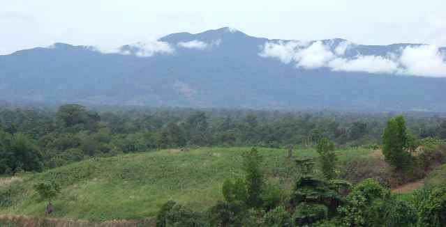
Gunung Gading

Lundu had electricity and piped water (from Gunung Gading) by the early 60s. Piped water came to Kpg. Stunggang Dayak in 1987, and electricity was extended to our kampong in 1988. The Lundu hospital was built in 1965, and now offers treatment for all except the most serious problems. They have a dental clinic and ultrasound screening for mothers-to-be. Until 1968 Lundu could be reached from Kuching only by boat. In that year the road from Bau to Lundu was completed and regular bus service began. This road remained a gravel-surfaced road until 1995, when the whole stretch was improved and asphalted.

Lundu Town

About 5,000 people live in or close to Lundu town. The total population of Lundu district was about 25,000 when figures last became available. People in Lundu make their living in traditional ways, by farming, fishing, planting cocoa, pepper, and rubber, although rubber is less important than it was. There is a smidgen of light industry, and the palm-oil plantations that line the Bau-Lundu road and across the river towards Sematan, together with the factories for the extraction of the oil, employ many people.  Trade to supply the needs of primary economic contributors is vigorous.  When the bridge over the Batang Kayan is completed, we are expecting new opportunities in tourism and other things.here